Soil compaction - objectives and scientific approach
Objectives:
The overall aim of this subproject is the tracking of field traffic induced dynamic soil load from the particular machinery to the subsoil and the specification of the effects on soil functionality in layered soils. Therefore different, mainly new, approaches will be developed and combined.
Scientific approach and methods:
Status quo of physical soil threats and strategies for different agricultural management
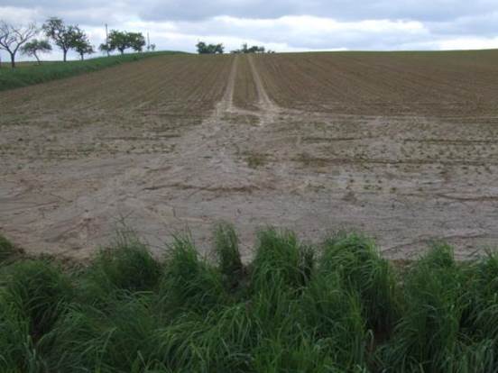
© Marco Lorenz, Thünen-Institut
- Ascertainment of the status quo situation of soil structural damages and soil compaction in Germany
- Listing of influencing factors and parameters based on available publications data from permanent observation plots and status quo assessments in different federal states in Germany
- Basic characterization (soil, crops, machinery) of cooperative farms
- Creation of strategies to avoid soil compaction and soil structure damages at different agricultural management
- Linkage between compaction vulnerability and the mechanical load caused by agricultural machinery (close cooperation with subproject: Acceptance and implementation of conservation measures in the field of soil compaction)
- Work is the basis of the subprojects:Socio-economic assessment,Optimization of land use strategies and agricultural management and Generating recommendations for farmers, advisory, and education
Developing a sensor system platform and device to simply measure soil pressure and soil deformation simultaneously
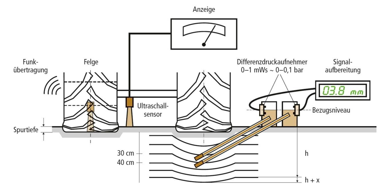
© Marco Lorenz
- Development of the sensor system platform will be build on existing work from Thünen Institute of Agricultural Technology and consists of 5 sensors
- One sensor is located in each rim to determine the tire deflection and wheel load and one sensor is located below the rear axle
- The wheel load and the track depth can be determined from the data
- Extension and adaption of the existing system and integration in the assistance system
- Statements about the contact area of every single tire and the contact pressure can be derived
- Linkage between soil and modeling of soil pressure and soil deformation in different soil depths
- Position parameters of the machine (e.g. slope) and an integration of a dynamic determination of yield can be derived
- Need of a new development of soil pressure measurement and an improved system to measure deformation
- This work is the basis for the linkage of soil pressure measurements and soil deformation measurements, the generation of recommendations for farmers und the modeling of soil pressure and soil deformation and thus for the development of the 3D soil model (basis for the assistance system
Measurement of the effects of field traffic on soil pressure, soil deformation, soil structure and different soil functions and on earthworm activity
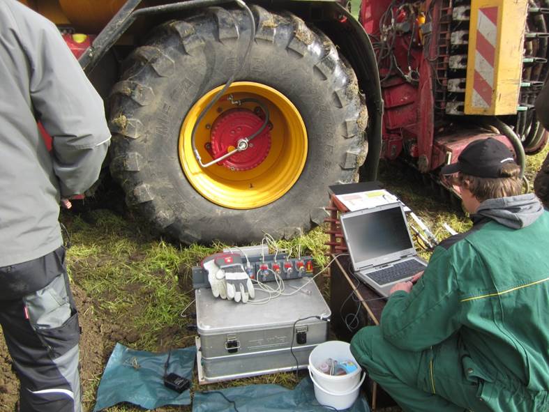
© Berthold Ortmeier, Thünen-Institut
- Based on defined machinery measurements comprehensive soil surveys will be conducted to specify the effects of agricultural field traffic on farmland, soil structure and soil functionality
- Within the particular examined field areas of different soil load will be identified and the soil samples (disturbed, undisturbed) will be analyzed in the existing laboratories
- Measurements of soil pressure and soil deformation
- To identify the changes in soil functions by field traffic soil samples will be taken before and after wheeling
- Parameters in the field: soil type, soil horizons, soil layers, soil structure assessment, penetration resistance, soil moisture measurement, earthworm activity, electrical conductivity, infiltration measurements, field variability
- Parameters in the lab (disturbed soil samples): particle size distribution, humus-/organic C-content, aggregation stability and size, cation-exchange capacity, pH value
- Parameters in the lab (undisturbed soil samples): bulk density, particle density, soil moisture, pF-function, parameters of soil water budget (air capacity, field capacity, usable field capacity, plant available soil water, permanent wilting point), saturated water permeability, unsaturated air permeability
- Parameters help to get changes in soil structure and soil functionality due to field traffic and soil load
- Results will be used for modeling and generation recommendations for farmers
Modeling soil pressure and soil deformation for layered soil profiles and their effects on soil structure and different soil functions
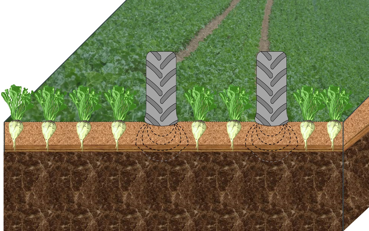
© Marco Lorenz
- Currently available models are not able to map layered soil profiles and to model soil pressure and soil settlement simultaneously
- Aim: A new modeling approach will be developed to model layered soils from topsoil to subsoil with regard to pressure propagation, soil deformation and elastic and plastic settlement processes
- First step: use of currently available data sets and results from the field measurements to implement a basic model (modeling of soil pressure and soil deformation of layered soil profiles)
- Second step: Integration of parameters detected by sensors as initial and boundary conditions
- Third step: use of results from field and lab measurements to connect the modeling results with the changes of soil structure and soil functionality to assess the effects of wheeling
- Linking between soil pressure and soil deformation modeling and spatial modeling to receive a 3D model
- 3D-soil-pressure-deformation-functionality-model to assess the extensive soil changes because of wheeling processes
- Linkage between real time sensor data and ‘on-the-fly sensor system platform’
- Basic element for the later on-board assistance system
Scroll to top